
Geographic Information Systems (GIS)
Specific Capabilities:
- 3D & 4D Modeling
- Geodatabase Design
- Data Interoperability (CAD, GPS)
- Complex Spatial Analysis
- Advanced Cartography
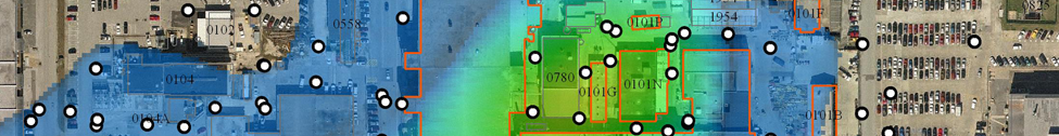
Geographic Information Systems (GIS) is an analytical and graphical tool used to organize, process, and display all types of spatial data. GIS is an essential component of Tetra Tech’s day to day business, providing cartography and database products to engineers and scientists across the company. The ISG GIS staff routinely perform complex spatial analyses, 3D modeling, and custom database development to public and private sector clients. Our GIS analysts are especially adept at illustrating complicated environmental datasets through visually concise maps, conceptual site models, and other graphics.
ISG staff employ GIS for a number of modeling applications that provide multidimensional spatial analysis and visualization for environmental data. Our GIS analysts use C-Tech EVS software and related GIS resources to model soil and groundwater contamination at various sites. We routinely analyze, process, and interpolate large datasets using complex spatial analysis tools. The GIS staff are adept at integrating and processing different types of data in a GIS environment, including CADD, GPS, LIDAR, and survey-derived datasets. In addition, ISG GIS Analysts work closely with our Application Developers in the creation and deployment of custom spatial tools, for visualization and database management.